Moisture in the Atmosphere
Water is probably the most important mass moved by the air/atmosphere, with temperature defining the condition or state of the energy held. Air is mostly in its highest energy state as vapour. But, as we well know in the UK, liquid (rain) and frozen forms (snow and ice) are common.
The amount of moisture in the atmosphere is relatively small, but highly varied in time and space. When air is holding the maximum amount of water vapour possible, it is said to be saturated. The water-vapour content of the air can be expressed in terms of its absolute humidity or, more commonly, in terms of its relative humidity: the percentage ratio between the actual amount of water and the maximum amount that the air can hold at that temperature.
Evaporation and condensation are two important phase changes in the hydrological cycle and are accompanied by the absorption and liberationrespectively of latent heat.
The main forms of condensation are clouds, mostly at high levels, and fogs, at or near the ground. These forms of condensation occur when air is brought to saturation point or its dew-point temperature. Condensation is assisted in the atmosphere by condensation nuclei around which liquid water can form. Condensation does not always lead to precipitation; gravity has to overcome the ability of air currents to keep the water vapour buoyant before this can occur. Most saturation and condensation in the atmosphere take place as a result of air cooling, principally by the vertical ascent of air.
Air is forced to rise and cool by:
- orographic uplift
- frontal uplift
- large-scale convergence and ascent in low-pressure systems
- smaller-scale convective currents.
Remember warm air holds more moisture than cold air. You need to be aware of these two methods of precipitation formation:
Bergeron–Findeison
Water droplets are lifted rapidly by turbulent air currents. Rapid freezing occurs and water vapour turns instantly to ice through sublimation. As ice falls from the clouds it melts and turns to rain. (Cloud seeding uses the same method! Supercooled clouds are seeded with dry ice and silver
iodide, etc.)
Coalescence theory
Water droplets grow in turbulent air. Large clouds form and droplets grow and eventually fall.
Collision in the clouds cause the drops to grow.
Types of precipitation include:
- rain
- drizzle
- hail
- snow
- sleet
- fog
- fog drip
- dew.
Stability of the air – Lapse rates
Advectional processes continually seek to establish a stable atmosphere, in terms of the distribution of energy. Air masses with their uniform temperature and humidity typify this stability. However, within air-masses parcels/pockets/balloons or bubbles of air must move vertically (or adiabatically) up or down, especially when air masses move over irregular relief or variably heated land masses. The stability or otherwise of these smaller bubbles of air has dramatic effects in terms of local weather.
In general, temperature falls as you move higher into the atmosphere, this is known as the ELR (Environmental Lapse Rate). As pockets of rising air gain height they cool, expansion occurs, further energy (kinetic) is lost and the pocket of air cools still further. So long as it is not saturated it cools at a fixed rate, the DALR (Dry Adiabatic Lapse Rate). Once the rising air reaches the condensation level it becomes saturated. Latent heat is produced and water vapour turns to water. Air cooling is now reduced, and the air now cools at a slower rate than previously. This rate is known as the SALR (Saturated Adiabatic Lapse Rate).
Remember: Adiabatic changes occur in a vertical direction and are due to internal pressure change, not heat exchange.
Temperature varies with height, i.e.:
- ELR = 6.5°C/km climbed
- DALR = 10°C/km climbed
- SALR = 6°C/km climbed
(These ‘rates’ vary at the same rate up or down!)
The relationship between the ELR and both the DALR and the SALR influences the temperature, and thus the density and buoyancy of a vertically displaced parcel of air, in comparison with its atmospheric surroundings. It thus determines the character of air stability.
Warm air parcels are less dense than surrounding air.
Image
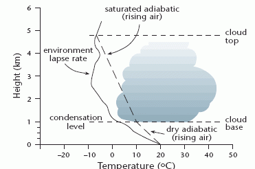
Unstable air occurs when a vertically displaced warm air parcel is encouraged to rise, at sufficient height it cools and condenses into clouds. In this case, the ELR is greater than the DALR or SALR.
With stable air, a parcel of air displaced vertically upwards or downwards in the atmosphere will tend to return to its original position. Here the ELR is less than the DALR or SALR.
Image
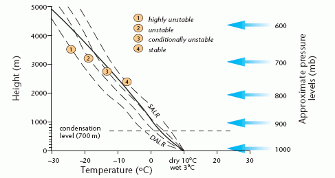
Air stability is an important concept as it determines the buoyancy of the air and thus development of cloud and fog. Cumulus clouds, often of large vertical extent, are characteristic of unstable air, whereas horizontally developed stratus clouds tend to form in more stable air.
Category