Severe Weather & related phenomena
Extremes of precipitation and temperature cause most of our weather hazards. Extremes of air movement surprisingly create more minor effects.
Tropical cyclones
These are classified differently around the world, cyclones hit Southern Asia (between June and November), the Willy Willies hit Australia (between January and March), and typhoons hit the western Pacific (between July and October). Typically these generate winds of between 40 and 119 km/hour. Hurricanes are also a form of tropical cyclone. The intensity of the hurricane and the extreme effects they have had on the Gulf coast of the eastern seaboard of the USA ensure that this form of cyclone has been well researched and documented.
18% of the world’s population live on coastal areas that are under threat from tropical cyclones. On average 20,000 people/year lose their lives to tropical cyclones.
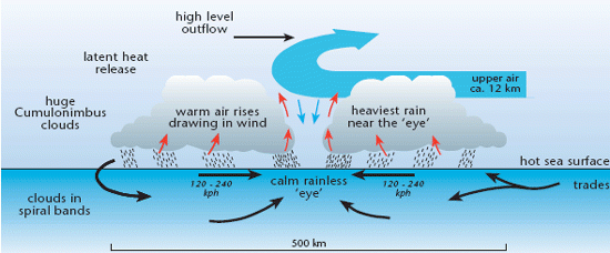
Hurricanes
Certain atmospheric and ocean conditions seem to be at the root of their formation. The following develops this ‘formation’ theme. Wind spins around an eye of 25 to 50 km this decreases in size as hurricanes speed up.
- Generally these intense low-pressure systems (less than 920 Mb is common) form between 30° N and S, in an area called the Intertropical Convergence Zone. With Coriolis Effect at its greatest in the tropics the systems’ rotation can be easily initiated (winds in the order of 119 to 300 km/hr are common). The ITCZ is where convergent air meets near the equator. This area is intermittent and can vary its position.
- The sea in this area is well heated, and exceeds the minimum 26° to 27°C necessary (between August and October) for latent heat to be released (because of condensation of water vapour) to strengthen the hurricane (relative humidity of 60% is common). The ocean then provides the initiating and sustaining energy for hurricanes. They quickly ‘die’ once they move onto the land. The high levels of moisture held also point to a sea origin (typically in the order of 10 to 25 cm/day).
- Towering (15 km is common) cumulo-nimbus clouds form around the central eye in highly unstable conditions. These clouds further fuel the hurricane as latent heat energy exchanges moisture from gas to liquid. Spinning weathersub-systems develop all around the main hurricane mass.
The effects of hurricanes include:
- storm surges – it is this phenomenon that potentially is the biggest killer. Hurricanes distribute energy polewards.
- damage to property (the power of the hurricane is such it turns property instantly into matchwood. e.g. Hurricane Andrew, in Florida, left 250000 homeless)
- agricultural damage
- huge insurance claims – when Hurricane Andrew struck in 1992, 25% of damage was paid for through insurance (some $5.6 billion), the federal government picked up the other $19 billion bill! Between 1900 and 1991 there were 152 direct hurricane hits on the USA.
- refugees – the 250 000 that Hurricane Andrew left homeless moved temporarily into other areas of Florida and into neighbouring states
- property – if all the debris from the properties that hurricane Andrew destroyed were to be piled up it would have towered 300 stories high!
- tourism – for Florida, hurricanes create a unique situation. It is a major tourist destination. Florida has suffered three of the five deadliest hits in the USA this century. Tourists are rightly wary of holidaying during the hurricane season in this state.
Examiners look for a good mix of process and factual understanding. Simple diagrams like this convey vast amounts of information extremely rapidly.
Image
Very occasionally hurricanes are re-vitalised in the mid-latitudes and therefore can reach the shores of Britain, though in an extremely modified form.
Newspapers are a good source of up-to-date information. AS questions frequently use this topic information.
Tornadoes
These are a concentration of cyclonically spinning air (about 160 km across), found overland, rather than over water. Most often a visible cloud forms from a large cumulo-nimbus origin. The tremendous rotations are initiated by rapid convergence at the base of the cumulo-nimbus cloud, as rapid updraughts develop. Tornadoes are common over the mid-west and southern states of the USA during the heat of early summer afternoons. Tornadoes are an increasingly common and observed feature in the UK, e.g. The Selly Oak twister of summer 1999, but perhaps more dramatic and bizarre was the Selsey Tornado, of 1999.
N.B. Tornadoes may be a by-product of hurricane development.
CASE STUDY - The SE Asian Monsoon
The word monsoon means season.
The SE Asian monsoon is the major disturber of the global atmospheric circulation. It displaces masses of energy to the North and South between 60° and 180° E.
Causes
- Pressure and wind
- The displacement of pressure and wind is caused by the direct heating of the Earth, this causes the land to heat up disproportionately to the sea. The Earth also cools disproportionately to the sea.
- The ITCZ/ITD (inter tropical discontinuity)
- Seasonal shifts of the ITD and its windy belts.
- Mountain influence
- Without the mountains, patterns of rainfall would be different in India.
- Concentrations of CO2
- Reduced CO2 over India, because the effect of uplift over the Himalayas causes less heat to be absorbed, which leads to cooling.
- Jet-stream positions
- In India the seasonal changes brought about by the above cause two markedly different monsoon periods.
The winter monsoon
Westerly jets split around the Tibetan Plateau. Descending air causes high pressure over central Asia resulting in out-blowing northeast winds across Asia, clear skies, and little rain. Sunny weather results.
The summer monsoon
Beginning in the spring and finishing about June. The phases of the summer monsoon are:
- in March the northern jet dominates the area
- the sun is directly over India
- the ITD moves to an area south of the Himalayas
- low pressure moves northwards – the so-called monsoon trough
- one part of the trough moves west over India, the other to the east over the Bay of Bengal, they meet and join over northern India in June
- low pressure continues to deepen and develop over the area and the North Indian Ocean. Under the intense isolation of the area’s clear skies, warm moist air starts the cycle of the so-called monsoon rains
- lots of warm moist air is drawn in over India from the North Indian Ocean: intense rainfall results.
The monsoon brings drought-breaking rainfall and wind, and invariably initiates devastating subtropical cyclones (e.g. Orissa, India 1999).
Impacts
Agricultural yields increase during the ‘good’ monsoon years. This has to be balanced against flooding and loss of life.
Category