Fluvioglacial Depositional Landforms
Fluvioglacial deposits and glacial deposits are often found in close proximity and sometimes overlying each other.
The fluvioglacial deposits can be distinguished from the glacial deposits by the rounded nature of the rocks they contain, and the fact that the deposits are both stratified and sorted (graded).
Kames and Kettle Holes
Kames are steep-sided mounds of fluvioglacial material of various shapes and sizes with a variety of possible origins.
Material transported by meltwater streams may be deposited in crevasses, in hollows on the ice surface, in spaces in ice tunnels. Once the ice melts, the material is dropped in a heap on the valley floor. These landforms although showing rounding of the larger deposits, may not be well stratified or sorted.
Kames formed by meltwater streams along the margins of ice sheets or glaciers may well show better stratification and sorting but these kame-terrraces also tend to collapse when the ice melts.
Delta-kames are formed when sub-glacial streams emerge into ice-contact lakes.
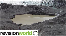
During deglaciation, ice sheets and glaciers break up leaving blocks of ‘dead-ice’ lying in amongst the fluvioglacial deposits that are being created. As these ice blocks melt, they form depressions or kettle holes which may have lakes in them.
Image
Sandar and Outwash Plains
The largest materials are transported only short distances but the finest silts and clays may be carried in suspension for many miles, only being deposited in very still water. Many of the meltwater streams are milky in colour due to the ‘rock flour’ carried in suspension.
The layers of deposits eventually form sandur or outwash plains which may cover huge areas and be over 50 metres deep.
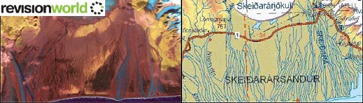
Skeiðarársandur in south-east Iceland, with an area of over 1,000 square kilometres, is the world's largest active pro-glacial outwash plain. It has a classic braided drainage pattern.
The picture below shows a geological survey and a map of the area.
Image
Eskers
Eskers are long, sinuous ridges of sand, gravel and pebbles that snake across areas of gentle relief.
Image
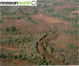
Some are only a few metres long but there examples which are hundreds of kilometres long and tens of metres high in Canada.
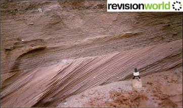
In cross-section, eskers show the characteristic fluvioglacial stratification and sorting of deposited material.
It is thought that eskers are formed in subglacial tunnels and that meltwater streams gradually built up layers of deposits which are exposed once the ice melts.
Image
The sinuous nature of the esker reflects the meandering course of the meltwater stream. Many eskers have been destroyed by modern-day quarrying for the sand and gravel that they contain.
Category