Meltwater Streams & Landforms
Fluvioglacial activity results from the enormous amounts of water released by ablation, particularly during periods of deglaciation.
In the past, research was confined to looking at depositional landforms and the processes that formed them but recent research has revealed the dramatic power of fluvioglacial erosion and its associated landforms.
Volumes of meltwater are highest in temperate glaciers, particularly in summer. Much of the water flows within and under glaciers under pressure (hydrostatic pressure) and so behaves differently to surface streams.
Meltwater streams are capable of transporting huge volumes of material and consequently, mainly through abrasion, carrying out large amounts of erosion.
Deposition of the load occurs whenever there is a decrease in pressure and/or velocity.
Image
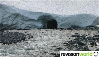
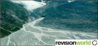
On the edges of ice sheets, a large number of meltwater streams transport an immense amount of sand, silt, clay and rock particles from the melting ice.
These streams merge, sometimes into a single tangle of waterways and the discharge of the channels varies both diurnally and seasonally.
As a result, debris is constantly being picked up and deposited. Such streams are referred to as braided or anastomosing streams.
Image
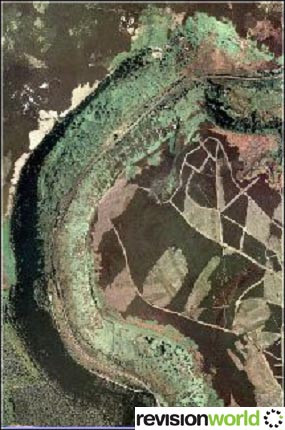
When meltwater streams flow into lakes, velocity is reduced and deposition occurs.
The load volume is directly related to the time of year and in spring, when discharge is greatest, lighter coloured and coarser deposits are laid down on the lake bed.
Towards the autumn, discharge decreases and a darker, finer layer of deposits is placed on top.
Each band of light and dark deposits therefore represents one years accumulation.
The layers or varves provide useful evidence of the age of the lake and variations in climate from year to year.
Glaciologists now take regular core samples from the lake sediments in glaciated areas to build up information about the glacial history of the area.
Meltwater Channel
It is now generally agreed that fluvioglacial erosion has played an important part in shaping many glaciated landscapes. Meltwater streams exhibit extreme discharges and load volumes which allow active abrasion of both bedrock and any deposited material.
The largest landform of fluvioglacial erosion is the meltwater channel. Meltwater channels have a number of characteristics which distinguish them from conventional river valleys.
Image
Although sometimes exhibiting valley dimensions, they are channels rather than valleys which must at some time have been full of water (bankfull stage).
- They are relatively short in length and may be intermittent i.e. they display gaps along their length.
- They tend not to widen downstream and in a modern non-glacial landscape are often dry, although some have misfit streams along their length.
Newtondale in Yorkshire (UK) is a classic example of a meltwater channel formed by the overflowing of a series of pro-glacial lakes.Newtondale is about 40 metres wide and 80 metres deep.
There are many alternative theories (other than overflow channels) for the existence of the meltwater channels.
Some are seen as marginal meltwater channels carrying water along the sides of glaciers at times of extreme ablation, probably during deglaciation.
Others are regarded as subglacial meltwater channels eroded to great depths by the power of the hydrostatic pressure in these subglacial channels.
Evidence of glacial lakes comes from the strandlines created by waves breaking on the shores of these lakes. The Parallel Roads of Glen Roy in Scotland provide some of the best examples in the UK.
Meltwater streams often deposited vast quantities of material in glacial lakes as deltas. These inland glacial deltas provide another valuable source of material to the quarrying industry.
The town of Pickering in Yorkshire is located on a large glacial delta formed at the end of the Newtondale meltwater channel.Many of the courses of the UK’s current rivers were modified in glacial times.
Interference with drainage patterns happened when traditional routes became blocked by ice or deposits left by the ice sheets and glaciers.
The River Thames formerly flowed much further north but was forced to adopt a more southerly route during the Anglian Glaciation.
Category