Depositional Landforms
Material eroded and subsequently transported by glacial ice may be deposited as unsorted till material as the ice melts or it may be further transported by glacial meltwater and then deposited as sorted fluvioglacial material.
Till deposits, sometimes referred to as boulder clay, are a mixture of unsorted sand, clay and rock particles. The rock fragments are sub-angular in shape.
The majority of this material has been transported as supraglacial debris and is dropped in situ at the glacier snout or more generally at the ends of ice ages when glaciers disappear.
Some of the till deposits form distinctive landforms but much of it is simply deposited as a layer which masks the former pre-glacial landscape.
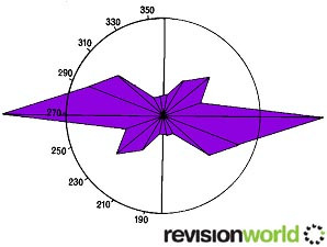
Till fabric analysis can be used to analyse the rocks embedded in the sand/clay matrix in order to determine the direction of glacier or ice sheet flow.
The long axes of the larger rocks align themselves in the direction of flow.
Image
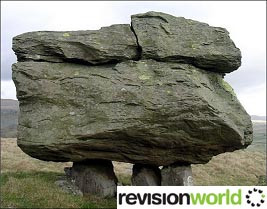
Sometimes glaciers pick up and transport rocks with distinctive geological characteristics. Once deposited, these erratics can be used to trace back the route followed by the glacier.
The photo shows a sandstone Norber Erratic in Yorkshire (UK) lying on top of limestone which has been chemically eroded by acidic rainwater in the 13,000 years since the boulder was deposited.
Image
Moraines
When glacial debris is deposited, five main types of landform may be created:
Lateral moraine
- Lateral moraine forms a ridge along valley sides.
- They are formed from debris originating from freeze-thaw activity on valley sides.
- The material falls onto the glacier and is carried mainly as supraglacial material.
- The material remains angular in nature.
Medial moraine
- Medial moraines, found in the middle of valleys, are usually formed when two glaciers coalesce.
- They are rare in post-glacial landscapes as they are easily destroyed by rivers flowing along the glacial troughs.
Terminal moraine
- Terminal or end-moraines are located at the snout of glaciers or the edges of ice sheets and mark the furthest point of advance.
- They are created from supraglacial, englacial and subglacial material when ablation is active.
- They form crescent-shaped ridges which can be several hundred metres high.
- Terminal moraines may act as dams at the edges of corrie basins or in glacial troughs.
Recessional moraine
- When there are long pauses in the deglaciation process, a series of recessional moraines, often smaller than terminal moraines, may form to mark the various stages of glacial retreat.
Push moraine
- If there is a major re-advance of the glacier or ice sheet, the end moraines are bulldozed forward to create push moraines.
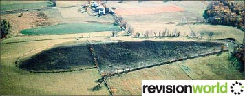
Sometimes, moraine material is shaped into low, egg-shaped hills called drumlins. These tend to occur in large swarms on valley floors or in lowland areas. They are blunt and steep at the stoss end, narrow and gently-sloping at the lee end. Valley drumlins are around 5-10 metres in height but lowland examples can reach 50 metres in height.
Image
Category