Periglacial Landforms
Ice Wedges
In winter, the active layer freezes and the soil layer contracts and forms natural polygonal patterns.
The following summer, the cracks may close up or sometimes become filled with meltwater and debris.
In the subsequent winter, any water filled cracks expand as ice forms and the cracks widen to form ice wedges.
Image
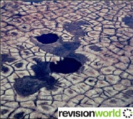
Repeated freezing and thawing leads to wedges a metre wide and up to three metres deep.
In the UK, fossil ice wedges can be found in many areas.
The cracks are filled with sand and silt deposited by meltwater.
Ice-wedge polygons can be distinguished from the stone polygons by their greater size (up to 30 metres across) and the depression, rather than a dome at the centre.
Pingos
In a periglacial landscape, the most dramatic landform is the pingo.
These are dome-shaped hills which may rise to around 50 metres above the generally flat tundra landscape.
Image
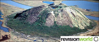
Some of the pingos have depressions in their surfaces and some have ice cores at their centre.
It is believed that the origins of these landforms may vary and two types are now recognized – the open system (hydraulic) pingos and the closed-system (hydrostatic) pingos.
Open-system (hydraulic) pingos occur in valley bottoms and in areas of thin or discontinuous permafrost.
They are common in East Greenland.
Image
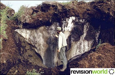
When the surface layer freezes, water is trapped in the talik (unfrozen layer).
This water comes under pressure and may move towards the surface where, surrounded by permafrost, it freezes into an ice core. This causes the surface to dome upwards. As water under pressure finds its way to the surface, the ice dome and thus the pingo, continues to grow.
Closed-system (hydrostatic) pingos are generally found in lowland areas where permafrost is more continuous.
They often form on the sites of small lakes.
Image
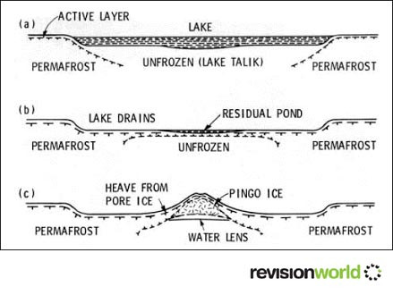
As these lakes fill with sediments from meltwater, the surrounding permafrost advances and squeezes the unfrozen sediments below the lake.
When the lake itself is frozen, the water in the underlying sediments causes the surface to dome upwards creating the pingo.
If the dome cracks, the ice core may melt leading to a collapse of the pingo and a pond forming in the central crater.
Category